


Cavalry Voting District, Snohomish County, Washington
About
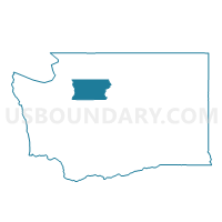
Outline

Summary
| Unique Area Identifier | 688522 |
| Name | Cavalry Voting District |
| County | Snohomish County |
| State | Washington |
| Area (square miles) | 1.31 |
| Land Area (square miles) | 1.31 |
| Water Area (square miles) | 0.00 |
| % of Land Area | 100.00 |
| % of Water Area | 0.00 |
| Latitude of the Internal Point | 47.84181680 |
| Longtitude of the Internal Point | -122.12551260 |
Maps


Graphs
Select a template below for downloading or customizing gragh for Cavalry Voting District, Snohomish County, Washington


Neighbors
Neighoring Voting District (by Name) Neighboring Voting District on the Map
- Battery Voting District, Snohomish County, WA
- Beecher Voting District, Snohomish County, WA
- Rainier Voting District, Snohomish County, WA
- Wheeler Voting District, Snohomish County, WA
- Woodshire Voting District, Snohomish County, WA
Top 10 Neighboring County Subdivision (by Population) Neighboring County Subdivision on the Map
Top 10 Neighboring Place (by Population) Neighboring Place on the Map
- Silver Firs CDP, WA (20,891)
- Maltby CDP, WA (10,830)
- Clearview CDP, WA (3,324)
- Cathcart CDP, WA (2,458)
Top 10 Neighboring Unified School District (by Population) Neighboring Unified School District on the Map
Top 10 Neighboring State Legislative District Lower Chamber (by Population) Neighboring State Legislative District Lower Chamber on the Map
Top 10 Neighboring State Legislative District Upper Chamber (by Population) Neighboring State Legislative District Upper Chamber on the Map
Top 10 Neighboring 111th Congressional District (by Population) Neighboring 111th Congressional District on the Map
Top 10 Neighboring Census Tract (by Population) Neighboring Census Tract on the Map
- Census Tract 521.18, Snohomish County, WA (6,843)
- Census Tract 521.08, Snohomish County, WA (5,814)
- Census Tract 521.14, Snohomish County, WA (4,988)
- Census Tract 521.07, Snohomish County, WA (3,975)